
Madaba Map: Exploring a Unique Piece of History
Tucked away in the ancient city of Madaba in Jordan lies a unique piece of history – the Madaba Map. This detailed floor mosaic was discovered in an Orthodox church in 1884 and is believed to be the oldest surviving map of the Holy Land. It is an invaluable treasure that provides us with insight into the region’s past as well as its current state.
What is the Madaba Map?
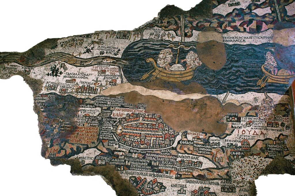
The Mosaic Map of Madaba, or the Madaba Map, is a 6th century Byzantine floor mosaic that was found in a Byzantine Church in 1884. It was created with over two million pieces of colored stone and is the oldest surviving map of the Holy Land. The map stretches over a large area and depicts the area from Lebanon in the north to the Nile Delta in the south and from the Mediterranean Sea in the west to the eastern desert and the Dead Sea.
The map is an extremely detailed representation of the area and includes many of the region’s major cities and towns. It shows all of the major biblical sites, including the Jordan River, the Sea of Galilee, Jerusalem, Bethlehem, Jericho, and more. In addition to the biblical sites, the map also depicts many of the major landmarks of the region, such as the Dead Sea, the Red Sea, and the Great Rift Valley.
The Significance of the Madaba Map
The Madaba Map is a unique and invaluable piece of history that provides us with insight into the region’s past as well as its current state. It is one of the earliest surviving maps of the Holy Land and has been used to study the history and geography of the region.
The map is also an important tool for archaeologists and historians, as it provides a wealth of information about the region’s ancient sites and places of interest. It has been used to identify and locate many of the region’s archaeological sites, such as the location of King Solomon’s Temple in Jerusalem.
The Madaba Map is also an important religious artifact as it depicts many of the major sites in the Bible. It is believed to have been created in order to help teach the Bible to those who were unable to travel and see the sites for themselves.
Exploring the Madaba Map
The Madaba Map is located in the Church of Saint George in Madaba, Jordan. The church is open to visitors and it is possible to view the map up close. The map is also available online, allowing anyone to explore it from the comfort of their own home.
Visitors to the church can also take a guided tour of the map, which provides an in-depth look at the map’s history and significance. During the tour, visitors can learn about the region’s biblical sites, its ancient cities, and its modern landmarks.
Conclusion
The Madaba Map is a unique and invaluable piece of history that provides us with insight into the region’s past and current state. It is an important religious artifact and an important tool for archaeologists and historians. Visitors to the Church of Saint George in Madaba can explore the map up close and take a guided tour to learn more about its significance.